
Overlooking Sea of Clouds from the summit
It was once my dream to climb the Philippines’ highest mountain until I decided to wake up and realize that dream. It was my first 2,954 meters (asl) climb and the feeling was enormously grueling. However, as there is no easy road to the peak, the reward is absolute priceless once you reach the summit.

Reach the summit
Brief Overview
Dubbed as the king of all mountains in the Philippines, Mt. Apo is a huge potentially active stratovolcano located between Davao City, Davao Del Sur province and Cotabato province in the island of Mindanao. It is considered as one of UNESCO World Heritage Site; habitat to numerous species of flora and fauna.
With a huge coverage of forest, sulfuric boulder and fair acre of a white sand landscape, it is divided into more than a couple of guided trails. And this time, we trekked the Sta. Cruz – Kidapawan trail.
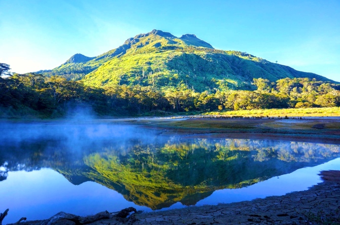
Beautiful landscape from Lake Venado
Basic Requirement
Secure a permit from Tourism Department or DENR offices before the climb. It can be taken from nearby offices where there are guided trails like Digos, Santa Cruz or Kidapawan.
Trail Guide or porter is required to accompany during the climb. You may book from a legitimate tour agency or registered mountaineers in town where there are guided trails.
Recently, a large part of Mt. Apo was affected by the forest fire, please check with the local government agency in advance prior to the journey as a limited mountaineer is only allowed to climb, perhaps, a zero-climb rule until fully recovered.
Fee (as of March 2016)
- Entrance Fee P1,000/person (Santa Cruz) price varies depending on trail site
- Exit Fee P1,500/person (Kidapawan) price varies depending on trail site
- Porter P500/day
- Transport to jump off site P250/person (Digos to Sta. Cruz)
Basic Gear
- Mountaineering Backpack (50 liters or up)
- Mountaineering boots / shoes
- Windproof pants and jackets (outerwear)
- Fleece / wool hat (for cold nights)
- Fleece pants / dry-fit shirts (innerwear needed during night)
- Liner socks
- Light / midweight underwear
- Water bottles (at least 5 liters)
- Sleeping bag (at least 10 degrees Celsius capability)
- Windproof & Waterproof tent
- Headlamp
- Trekking pole (optional)
- Mug, bowl, and utensils
- Knife / Multi-tool
- First aid kit
- Snacks / Foods (dried & packed foods recommended)
- Toiletries / Personal kit
Level of Difficulty: 8/10(moderate to difficult)
Fitness Requirement: At least a month of training ahead of the climb like cardio or core strength exercises.
Mountaineer’s Creed: “Take nothing but pictures. Leave nothing but footprints. Kill nothing but time. Bring nothing but memories.”
Best Time to Climb: March to April (summer months)
The Climb
Basically, the journey begins by taking a 2-hour ride from Digos City to Sta. Cruz jump off site where a local porter is waiting. After a short orientation, start to ascend into an 80 degrees elevation hill going to the small barangay (village) of Tumpis. A barangay officer will check the permit prior to the climb. Although the summit is just 10.07 kilometers away from Sitio Tumpis, it takes a tedious 4-hour traverse going to Tinikaran Campsite 1 without even reaching half way to the summit. If you don’t like night trek, stay at Tinikaran Campsite 1 for a night rest.

From the Tinikaran Campsite 1, the challenge begin as the elevation becomes steeper. It takes 6 hours to the peak passing Tinikaran Campsite 2, dry river, bamboo bushes, sulfuric boulder face and white sand landscape before reaching the crater. Grab your camera as the 360 degrees view from the crater is absolutely stunning. Head your way up to the summit before going down to the campsite (which is just a few meters away). Have fun watching the sunrise and the sunset over the sea of clouds while noticing the gust of cold wind moving in faster velocity.


The following morning, descend through Kidapawan trail going to the mysterious lake Venado. It takes a maximum of 4 hours trek passing a mossy forest, thick bushes, and thorny wild berries. It is in Lake Venado campsite where you can capture the best view of the mountain – so don’t forget to save an extra battery kept in a warm bag as the cold weather will totally drain the power. If you’re up for mystery, take a night stay in Lake Venado campsite, wake up at 3 AM and witness the fantasy when the mountain is hugged by thick clouds in its magnificent circular formation. During the early morning, observe the surrounding when grasses are covered by thin ice fogs which slowly melts as the sun rises.


From Lake Venado campsite, another 6 to 7 hours of tiring descend to the proper town of Agco, so get ready to prepare your legs from a numerous 90 degrees elevation. Correct! You read it right – 90 degrees. Silently praise heaven as you cross the waterfalls, huge trees, flowing rivers, noisy geothermal plant, hanging bamboo bridges, local farmlands and slippery pandan leaves scattered everywhere. Then exit along a curvy highway where a government local unit officer is waiting to collect the exit fee and garbage. Stay a night in one of the hot spring resort in town and soak yourself into the hot pool (courtesy of nature’s hot spring) – it gives relief to the muscle pain.
Better yet, visit some other attractions nearby to wrap up your adventure.
Tell me how did you fare your climb so far?
Happy adventure!


I really like this post. The pictures you’ve included are amazing:D
LikeLike
Thank you so much.
LikeLiked by 1 person
Hi, May I please ask what model of salomon shoes are you wearing in this climb? We are planning to have the same trail as yours early next year and i’m not sure if my Speedcross 4 is up to the task considering it’s very slippery on mossy/wet rocks.
LikeLike
Hi Jenny. Apologies for late reply. I think I also used the same model. Doesn’t matter what the model is as long as it is for climbing. Certain areas are wet but you can always rely to the roots or trunk of the trees. Enjoy and take care.
LikeLike
May I know who organized your Mt. Apo hike? Who is your guide. May I know his/her contact information? Asap please. Message me on facebook, Im not using my email account. Please.
LikeLike
Sorry, but I can’t message you on FB. Message me instead Pearlits Page
LikeLike
Hi Sir! How many hours did it take for the whole trek po? Safe po ba sa hindi masyadong nagbubundok?
LikeLiked by 1 person
Hi Jassie. We took 2 days to go up and 2 days to go down including our overnight stay at the 2 campsites. Honestly, I recommend doing an endurance exercise beforehand so not to injure and hurt yourself. The place is so safe as long as you have a local guide with you which is affordable to hire. Enjoy climbing.
LikeLiked by 1 person
Noted on this, Sir. Thank you very much for the tip. I hope we can make it to the summit safe. Enjoy travelling the world, Sir! 🙂
LikeLiked by 1 person
You will surely make it Jassie. Have fun!
LikeLiked by 1 person
Thanks, Sir! I will po. 🙂
LikeLike
Pwede po manghingi ng contact person dito para ma-arrange po climb namin? DIY lang sana thanks for o
ocular visit
LikeLike
Hi Trippers.PH. Apologies for the super late reply. Unfortunately, I lost my old phone and all contacts were lost too. I will try my best to ask a friend is she has it.
LikeLike
Hi. Which tour or event coordinator would you recommend to do this hike via Kidapawan-Sta Cruz trail
LikeLike
Hi, I saw this blog. May I know who is your guide or travel agency?
LikeLike